
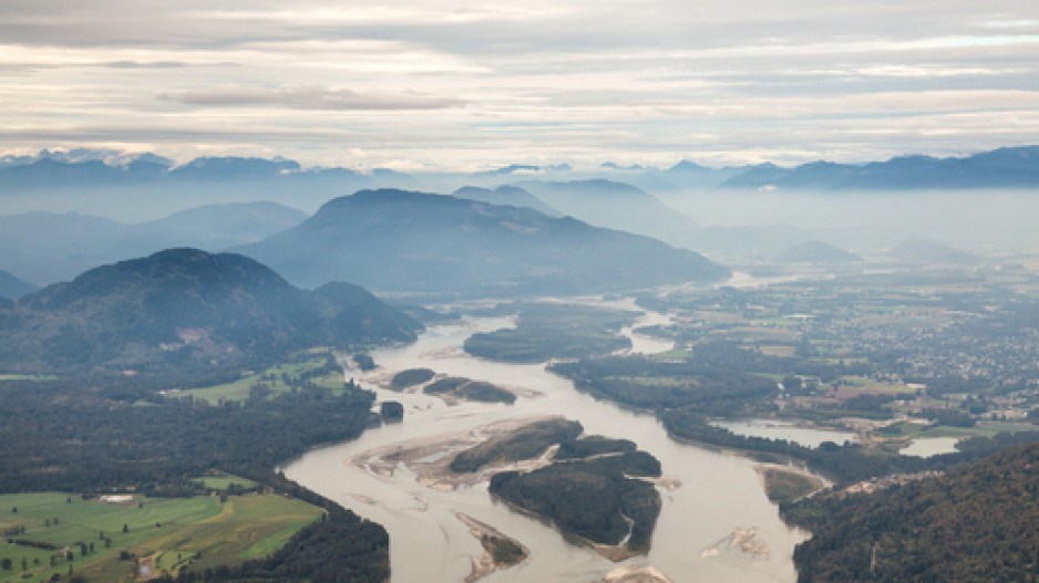
The Lower Mainland’s food security, transportation links and power supplies are at risk if an estimated 42 percent of the Fraser Valley floods as a result of climate-change-induced spring runoffs, government documents say.
“The potential for flooding off the Fraser River caused by a rapid snowmelt (freshet) is a seasonal threat that could impact almost 30,000 hectares (74,100 acres),” said a B.C. Agriculture & Food Action Climate Initiative Dec. 14 request for proposals. The $77,500-budgeted plan is to prepare a disaster mitigation toolkit for the agricultural sector.
That preparation plan price tag is in stark contrast to the estimated worst-case scenario tab of $32.7 billion envisioned by the Fraser Basin Council (FBC) for what could be Canada’s most-costly natural disaster.
A Fraser Valley Regional District (FVRD) report said climate change is anticipated to increase annual water peak flows, and shift them to earlier in the spring.
“A major flood event ... would cause over $800 million in damage to farmers’ crops, buildings and equipment, and the agricultural losses and associated spin-off impacts would have a have an economic impact of $1.1 billion on FVRD communities, the FVRD said.
Further, reports said, the combination of sea level increases and runoffs could increase flooding as far inland as Mission.
Problems Recognized in 2011
As far back as 2011, the Ministry of Health recognized the threat climate change poses.
“If global warming continues unabated, worsening climatic conditions in B.C. are likely to adversely impact food security through: physical degradation of land and water used in agriculture; biological changes such as increased plant and animal pathogens in staple crops; and destabilization of communities through degradation of local agriculture and lost jobs and incomes, directly reducing the ability to purchase food,” a ministry report said.
The threat has prompted the province to begin planning for managing flood-damaged crops, handling livestock, risks to farms and ranches, protection of farm structures, containing flood-borne contaminants and maintaining essential services.
The region produces 90% of B.C.’s poultry products, 72% of dairy cows and significant volumes of fruit and vegetables from outdoor or greenhouse production, according to Ministry of Agriculture 2016 statistics.
The provincial Ministry of Agriculture said it’s committed to assist food producers to ensure the food supply.
“Along with the federal government, we have invested approximately $3 million to help farmers and ranchers across the province prepare and adapt to changing climate and weather conditions,” a ministry statement said.
Regional agricultural strategies have also been developed in Peace, Cariboo, Thompson-Nicola, Columbia-Shuswap, Lower Mainland, Vancouver Island and Okanagan areas.
Agricultural producers did not respond to requests for comment.
Energy Security
It’s not just agriculture that is at risk. The Lower Mainland’s energy security could also be in danger, with power lines from northern B.C.’s massive Bennett Dam and various oil and gas pipelines, including the controversial Trans Mountain Pipeline carrying oil from Alberta to Burnaby, winding through the region.
The FBC report said all but one of BC Hydro’s 10 sub-regions have transmission lines in areas vulnerable to flooding. While transmission line towers are elevated, the bases are vulnerable to erosion that could lead to their toppling.
“Foundations of transmission towers are undermined through erosion, or if power lines or other infrastructure “If high-voltage lines are downed, this could disrupt power to multiple substations and have wide-ranging impacts, “ the report said.
Moreover, the report said, a loss of power to sewage plants could lead to sewage backups and raw sewage flowing into the Fraser River or directly to the Strait of Georgia.
BC Hydro media relations advisor Tanya Fish said the Crown corporation has been modelling flood risk potential in the Lower Fraser Valley for several decades.
That data has led to moves including raising or relocating power line structures, reserving materials and equipment required for emergency response and preparing stations and office buildings to prevent water entry and inundation.
“Our steel transmission structures have robust foundations that are either steel bolted to concrete or deep-buried steel lattice,” Fish said. “Wood pole structures are buried deeply enough – based on the soil conditions – to prevent movement.”
She added BC Hydro monitors snow survey bulletins and forecasts from the BC River Forecast Centre and Emergency Management BC.
Trans Mountain spokeswoman Ali Hounsell said flooding potential is factored into pipeline design. She said flood advisories and river flows are monitored and that the company “engages with provincial emergency management personnel when flooding is a threat. “
“We have assessed potential impacts from Fraser River flooding and have instituted measures to protect the pipeline and pump station facilities that could be threatened by flooding in the Fraser Valley,” Hounsell said.
Transportation Security
Flood waters also threaten rail and road transportation links running close to the river.
The Ministry of Transportation and Infrastructure said in a statement work is continuing with Emergency Management BC, local governments and various agencies to determine how to manage transportation issues during large-scale disasters. All highways are designated as emergency response routes, and work is done with local governments to identify municipal roads for emergency use.
The Regional Transportation Management Centre (RTMC) in Coquitlam would lead response and recovery efforts of the transportation networks as well as communicate to emergency responders.
Part of ministry planning has been to ensure all new bridges are built to withstand a minimum estimated 200-year flood level.
Documents show the RTMC which is built to a 100-year flood level and located 700 metres from the Fraser River at an elevation of 11 meters. It is, however, constructed on a floating slab with 544 stone columns enabling it to move with the ground during a seismic event and withstand uneven settlement of soils under the foundation, the ministry said.
Canadian Pacific Railway spokesman Salem Woodrow said, “CP engages regularly with local stakeholders in flood mitigation and emergency preparedness,” while Canadian National Railway declined to comment.
Contact this reporter at [email protected]


