
Could the 2014 Mount Polley tailings pond disaster have been prevented?
Perhaps not with the low-tech tools currently used to test for geotechnical instability. After all, a geotechnical panel struck to investigate the disaster determined the collapse was triggered by an unstable foundation of glacial till, and that no amount of testing could have predicted the collapse.
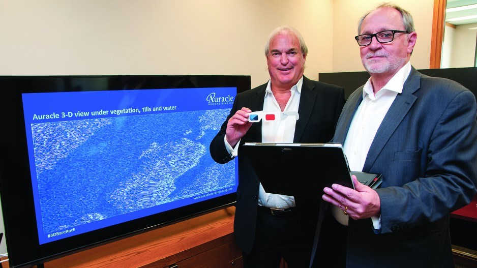
But the CEO of Auracle Remote Sensing said his company’s technology, which not only maps what is going on at the earth’s surface, but also determines what lies below, might have detected subterranean shifts that could have given some warning that the dam’s foundation was becoming unstable.
“There is a high likelihood that we would have picked up on it,” said David McLelland, CEO and founder of the Vancouver-headquartered company.
And while the company’s technology is already being used by mining, exploration and oil and gas companies – Enbridge Inc. (TSX:ENB) is one of its clients – the biggest new market is in monitoring infrastructure.
This was underscored recently when the company signed a memorandum of understanding with Tetra Tech (Nasdaq:TTEK), one of the world’s largest engineering firms.
“One of the things that’s recently changed in the company is in its direction, based on monitoring of infrastructure,” said Auracle executive chairman Stephen Leahy.
Founded in 2009, Auracle Remote Sensing uses satellite and radar data to generate maps of the earth’s surface.
It can also show what’s going on below the surface. Think of it as Google Earth, with X-ray vision.
“We can see below the dirt down to bedrock, and we can see below water,” Leahy said.
Using satellite radar imaging to look below the surface isn’t new. Ground-penetrating radar has been used for several years now to locate archeological sites, for example.
Auracle’s innovation is the use of “stereo radar” to come up with a more refined map of what’s going on below the surface of the earth or water.
Basically, the company takes radar readings from two different angles to come up with a more detailed map of what’s going on beneath the surface of soil or water.
“When you combine different aspects of the radar data, you have something that will penetrate certain types of material,” McLelland said.
“The evidence of that was shown in National Geographic and Scientific American, where they’re using it to discover archeological sites that were previously unseen.
“But we were the first to really combine stereo radar to eliminate noise and enhance the signal. We’re using stereo radar – in concert with shortwave infrared and optical data – to be able to produce a signal that is extremely low-noise, and as a result we’re seeing things that have never been seen before.”
McLelland has worked with mineral exploration companies for most of his career as an expert in remote sensing.
He has served on the technical advisory committee for the Geological Survey of Canada, and sat on the board of directors for the Association for Mineral Exploration British Columbia for 15 years, serving as chairman for the last two years. Leahy’s background is also in mineral exploration, but as a venture capitalist.
Auracle uses satellite data from MacDonald, Dettwiler and Associates Ltd. (TSX:MDA) and DigitalGlobe Inc. (NYSE:DGI) – the U.S. satellite company that MDA is in the final stage of acquiring – to create its maps.
The company collects continuous satellite radar data, shot from two different angles, along a 150-kilometre-wide swath. Periodic updates are then done, with the new map laid over the old one to detect any changes that might suggest erosion or fault-line shifts that could jeopardize critical infrastructure such as roads, pipelines, bridges and railway lines.
“The earth moves, so what we are doing is measuring, in minute scale, this movement, and we can tell over a period of time the rate of movement, the acceleration, deceleration or what exact direction it is,” Leahy explained. “This is a big deal for pipelines and big deal for railways.”
In anticipation of a growing global market for its geospatial data for monitoring infrastructure, the company has been busy opening sales offices in cities around the world, including Calgary, Copenhagen and Buenos Aires.
“We are on the cusp of enormous growth,” Leahy said. “We’ve done our homework, we’ve done all the bench tests for all the non-believers, and we’ve passed them all. So it’s really a question of serious marketing from here.”


