
A former B.C. meteorologist with more than two decades in forecasting is warning the public about the upcoming storm coming to the province.
“In my 20 years of forecasting, I've rarely been so concerned about a weather forecast,” Matt MacDonald, who previously worked at Environment Canada and as a meteorologist for 20 years and is now the lead forecaster for BC Wildfire Service, said in a social media post.
MacDonald deferred to Environment Canada when asked to speak to a reporter on the record. But in Twitter, he warned of a freezing rain event coming to the Fraser Valley over the next few days saying it will have “major impacts.”
"If I could tell all my friends, colleagues and contacts to avoid the valley on Friday-Saturday, I would. Dec 21 and 22 are great travel days between the Coast and Interior. Dec 23-24 will be horrific," he wrote.
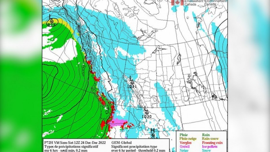
Numerous weather warnings have been issued for B.C. including a winter storm warning for Fraser Valley calling for heavy snow, ice pellets, freezing rain, and rain on snow or ice. Environment Canada expects freezing rain will come next.
This winter storm is expected to start Thursday evening and run into Saturday night in some locations.
An Arctic outflow warning has been issued for British Columbia's South Coast region, calling for bitterly cold conditions Thursday into Friday, with temperatures dropping to minus 20 degrees Celsius and winds reaching 70 to 100 kilometres per hour.
On southern Vancouver Island, the coldest temperatures are expected to continue until Thursday afternoon.
A winter storm warning bringing freezing rain, strong winds, arctic cold temperatures and flooding is coming to the South Coast of British Columbia on Thursday into Saturday.
MacDonald warns that the arctic outflow pattern means road surfaces will freeze triggering potentially dangerous conditions.
"As a major coastal valley, the Fraser Valley holds onto Arctic longer than most,” he says.
He describes this incoming storm as a category two out of three atmospheric river that will bring 50 to 80 millimetres of rain and freezing levels climbing to above 2,000 metres over the South Coast.
"The rain falling into the icebox that is the Fraser Valley will freeze on immediate contact with the ground/roads/bridge decks/power lines/structures and create an instantaneous coating of sheer ice,” he says.
The next 36 hours in the Fraser Valley will be “very bad” and a “very messy meteorological medley.”


